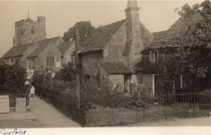
St Peter’s Church and cottages
Cowfold lies in the Sussex Weald, 8½ miles (13.5 km.) south-south-east of Horsham. The parish is compact and regular in shape, stretching 3 miles (5 km.) both north-south and east-west. It has been closely associated with Shermanbury about 3 miles to the south. The boundary between the two parishes in part follows minor watercourses, in particular the Cowfold stream. The eastern boundary, which also separated West from East Sussex until 1974 and Bramber rape from Lewes rape, is marked for two stretches by Spronketts Lane and Wyndham Lane; the western boundary largely followed minor roads until 1933.
The area of the parish was 4,501 acres (1,821 ha.) but in 1933, 121 acres (49 ha.) of High Hurst, lying beside the north-west corner of Cowfold parish, was added. Today the parish has a land area 4,756 acres (1,926 ha) and has therefore barely increased in size since 1933.
The land is gently undulating, falling from 300ft.in the north-east tip to 25 ft. in the south. It is drained by the Cowfold stream, which enters the parish just below the man-made Furnace pond in Lower Beeding and runs slightly west of south. The parish lies predominantly over Weald clay, which in turn overlies Upper Tunbridge Wells Sand except along a tongue of land running from the north-east corner almost to the centre; there are two patches of gravel in the south-east quarter, and five narrow bands of Horsham Stone running east-west. There were brickworks in 1875 and 1909 in the north part just east of the Horsham road, at a site marked in 1984 by Brick kiln Cottages, and brickfields southwest of the church at the centre of the parish in 1896 and 1909. In about 1890 stone was quarried at High Hurst and at three places in the north-east quarter, and there were gravel pits towards the north-east corner and a sandpit near the south-west corner. None of those sites seems to have been in use in 1909 but the quarries at High Hurst were revived for a time by 1922.
Although no documentary evidence earlier than the 13th century has been found for Cowfold or any place within it, in the 11th and 12th centuries the land seems to have been used for woodland pasture, (suggested by place names incorporating the words “den”, “fold”, and “hurst”), and for hunting. In 1210 Beeding manor had outlying farms in Cowfold and therefore the village may have enjoyed herbage rights in those parts of the Weald belonging to the manor.
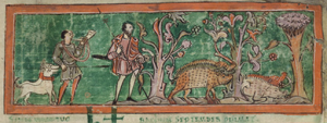
An 11th-century depiction of boar hunting from the September page of the Cotton Tiberius Calendar (© British Library Board, Cotton Tiberius B V f.7r)
Hunting may have taken place in the various parks that were established over the Cowfold parish. In 1256 the bishop of Chichester’s chase (called Gosden chase) extended down the whole east side of Cowfold parish between Warninglid (in Slaugham) and Wyndham, across to the south-west corner at Mockford, and from there to Parkgate near the centre of the northern boundary of the parish. Shermanbury and Ewhurst parks extended from Shermanbury parish over the south side of Cowfold. Additional parkland in the north-west quarter of the parish was made from the Woldingfold estate in the 1870s; vestiges of this remained in 1984, together with the west, south, and east lodge cottages.
A large proportion of the parish was woodland or orchard and remained so up to 1733. The woodland was most extensive in the north-east of the parish. No evidence has been found of open fields in Cowfold. Eight small pieces of waste in the south-west corner of the parish, in total just over 1 acre, were enclosed by an award of 1872.
The scattered settlement of Cowfold parish may represent the gradual and progressive establishment of outlying farms on what had been woodland pastures belonging to manors centred further south and to the north. Across the southern side of the parish nearly all the farms in the east and most of those in the centre belonged respectively to Shermanbury and Ewhurst manors, whose other lands lay immediately south, while those in the west belonged to Stretham manor in Henfield, about 4½ miles due south of Cowfold. In the northern two thirds of Cowfold parish the estates of those three manors were intermingled, except that the farms in the eastern half of the northern third belonged to Beeding manor, about 9 miles south-west of Cowfold.
The enclosure for cattle which gave the parish its name is likely to have been on Beeding manor land and may have been either in the north-east quarter where the manor’s lands were concentrated or near the site of the church where the manor had waste ground. By 1210 the perquisites and tallage payable from the vill of Cowfold to the lord of Beeding manor indicate a permanent settlement from that manor, and by 1257 the Cowfold tenants, customary and free, of Stretham manor formed a group distinct from their fellows in Henfield.